


Monday
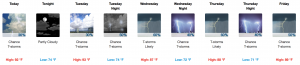
Looking at a high of 92º today with a heat index in the mid-to-upper 90ºs. popcorn shower and storms. Not everyone will see one, but if you do, be prepared for heavy rain and gusty winds. Chance of rain is at 30%.
This morning’s run of the HRRR model is below.

This model predicts fewer storms compared to yesterday.
Tuesday
Same story as today. Pop up showers and storms with a high of 93º after a morning low of 74º.

The Next Weather Maker
The second half of the weekend looks wetter. NWS Nashville broke it down this morning in their area forecast discussion:
So, any way you slice it, an unstable summertime weather pattern is expected to be in store for the mid state region Thursday thru next Monday…As a result, variable sky conditions are to be expected. On average, scattered showers and isolated thunderstorms will be possible thru the next weekend. One exception to this will be numerous showers and thunderstorms will be possible during the day on Thursday.
So basically, keep the umbrella and rain jacket close.

Severe Weather? There is no indication of organized severe weather throughout the week ahead. However, a few of the afternoon storms could reach severe thresholds in isolated locations. Lightning should accompany the heavier downpours.
As always, we are watching. Check back to NashSevereWx on Twitter for updates.

 Log In To Facebook To Comment