


RELIEF!
Yesterday’s relatively cool weather will carry over to today! Only expecting a high of 83º! Woohoo!
That said, we have a chance of a passing shower during the daytime hours. No storms, just a splash, and dash here or there.

Humidity will not be all that bad today. Dew points will be in the upper 60s, so noticeable, but not oppressive.
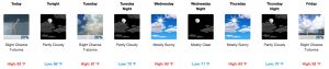
After today, we will see a steady rise in temperatures and in the dew points. Nashville is expected to be in the 90º range for temperatures, and the 70º range for dew points, by Wednesday.

Humidity and temps return to full blast by Thursday, but no rain is expected. We may get hot and humid enough Friday afternoon or evening to pop off a shower or weak thunderstorm. We will keep an eye on that.
Next Weekend Guess: Looks Rainy
Still looking rainy next weekend. Here is the latest from NWS Nashville:
Models have been pretty consistent with this solution, which may have more isolated showers and storms Saturday and widespread precip during the day on Sunday. Both the ECMWF and GFS have the upper trough digging southward into the early part of next week, which will keep higher precip chances in the forecast on Monday into early Tuesday.
Stay close, we are always updating the forecast on our twitter page: @NashSevereWx!

 Log In To Facebook To Comment