


This afternoon, a severe thunderstorm developed in Maury County. By late afternoon, rain cooled air from that thunderstorm raced north and set off severe thunderstorms in Williamson then Davidson Counties. Hardest hit was Belle Meade and surrounding communities. High winds brought down trees and power was lost. We got several reports of small hail. Torrential rains caused localized flooding.
Post Road? More like There’s a Tree In The Road! pic.twitter.com/A2ouGqebSm
— J.R. Lind (@jrlind) May 20, 2018
For more, see the #tSpotter reports on Twitter, our replies, or on our page here.
The storms took all the power and energy out of the atmosphere for tonight. Expect things to quiet down.
More Rain Possible Again Monday & Tuesday
Why? Because it’ll be more humid and it’s still going to be hot. Precipitable water values (PWAT) will be 1.5″ to 2.0″, which is a lot water for the atmosphere to tap. There will also be plenty of energy for storms to feed from. With plenty of heat both days, showers and storms should break out both afternoons and linger into the evening.
Exactly when or where rain and forms may form is impossible to say, and it’s possible rain will miss us altogether, or dump 1″ on someone’s backyard. NWS Nashville forecasts less than a quarter inch, but actual backyard rain totals will vary wildly in Davidson & Williamson Counties.
From NWS-Nashville, talking about Monday:
With storm motions even slower than today with the absence of any strong upper wave, and weak shear as well, showers and thunderstorms that develop in the afternoon will be able to produce heavy rainfall in a short timeframe. Any localized areas that receive training of storms or any stagnant heavy rain from
slow storm progression may receive flooding, in addition to any gusty winds and small hail with the stronger cores.
With more rain comes more cloud cover, so high temps should only top out around 86º.
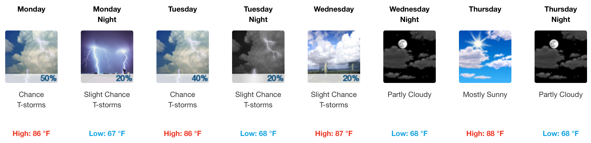
High Pressure Returns Wednesday & Thursday
Still, it’s possible heat will lift our humid air. Isolated showers and storms are possible (yet not likely). These are the two days most likely to be dry this week. Thursday looks best.
Friday & Next Weekend
High pressure will be replaced by low pressure, which will help along the process of rising air and improve rain and storm chances. Also, a tropical system may be trying to move in to the southeast next weekend. Rain chances Saturday are good.

 Log In To Facebook To Comment