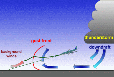
What is a gust front?
Suppose you have a cluster of storms producing heavy rain, like we saw this morning.
When that rain falls, it brings wind with it. That wind hits the ground and has to go somewhere, so it moves away from the storm. And because there is rain-cooled air in the storm, what we get is rain-cooled air moving along the surface and away from the parent storm.
Storms usually form in a warm environment. When that rain-cooled air starts moving along the surface beneath the warmer air already in place, it causes the air to rise. Clouds form, rolling away from the parent storm. Viola! A gust front (aka an “outflow boundary”) is born.

The gust front often takes the form of a roll cloud or a shelf cloud, like a giant UFO preparing to attack.
You could see the gust front on radar from earlier this morning:
Here’s a more pronounced one I found from somewhere else, thanks to Google:
Gust fronts can carry rain, but usually they just deliver a cool, refreshing breeze. Often, they lay down boundaries upon which future storms form.
Science!

Today – Rain, Storms Mostly to our North – High 84°
Humidity is returning, being blown in here by a SW wind. Below is a NAM Surface Dew Point map (for some reason on this map, blue means higher humidity).
According to the NWS, this will cause thunderstorms to be “likely” all day and we will hold on to a “chance” overnight.
The NWS has issued a Hazardous Weather Outlook.
That said, the HRRR weather model thinks most of the storms will stay to our North, in KY, with only a few showers here through midnight. RAP and NAM4km models agree. So, mostly dry.
Current Radar:
Friday – Thunderstorms Likely – Wake Up 65°, High 80°
The aforementioned surface front will begin to slowly push south on a northerly flow as an upper level disturbance approaches from the NW. The National Weather Service believes that thunderstorms will be likely all day into the evening hours. Additionally, the NWS thinks that areas along and north of I-40 will have more showers and thunderstorms than areas to the south.
The NAM’s Surface Level Pressure and Precip map shows showers beginning between 7 AM and 10 AM.
As the day progresses, the activity will drift further and further south.

Friday night looks pretty wet, and potentially stormy. Observe lightning safety protocols, y’all.
Saturday – Thunderstorms Remain Likely – Wake Up 59°, High 67°
An upper level low will dig into the SW US and help usher in more humid air into Middle TN. This will push this pesky surface front north across Middle Tennessee once again. The NWS believes thunderstorms will be likely – but not necessarily continuous – throughout the day and night.

Various weather models agree with this. The weekend looks pretty wet. About 1.5″ (and maybe more) of rain is expected through Sunday morning:
According to the Storm Prediction Center, no storms are forecast become severe severe of the next few days. Our best chance for severe storms will be Monday night Into Tuesday… We’ll keep you posted!
Extended:
This website supplements @NashSevereWx on Twitter.


 Log In To Facebook To Comment