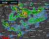
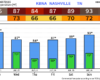
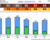
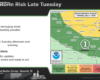
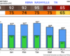
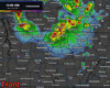
Normally there is at least something to write about in these blogs.
Today – and really most of this week – will be the rare exception.

We have no rain chances thru the end of this week, even creeping into early next week.
Normally there is at least something to write about in these blogs.
Today – and really most of this week – will be the rare exception.

We have no rain chances thru the end of this week, even creeping into early next week.
Not much has changed regarding the forecast for our showers/storms expected to move in later this afternoon and evening.
The only real change is that the Storm Prediction Center has introduced a 5% chance of damaging straight-line winds within 25 miles. No tornado concerns today.
The remainder of our Friday will be dry and warm. As of 2:30p, temperatures are in the mid 80s, flirting with our daily record high of 86° set back in 2012.
The first half of Saturday will be nice. We’ll warm back up to the low to mid 80s.

Dry and borderline hot today. Current forecast high temp is 85° – our daily record high is 87° set in 2012; we’ll see if we give it a run for its money.
A few showers will be possible Friday AM, but think most of us will be dry. Also, can’t rule out a quick shower/storm during the afternoon – but again, think most of us stay dry. High temperatures will yet again challenge the daily record high (86° set in 2012).
If you thought March felt abnormally warm – you’d be correct. It was actually the 2nd warmest March on record with an average temperature of 60.3° (warmest is 61.1° in 2012).
No April Fools jokes here – just high temperatures continuing to be ~20° above average.
We’ll wrap up March today right on theme for the month – very warm.
High temperatures will get into the low 80s, about 20° above average.
These temperatures will stay consistent throughout the week, as we rattle off five consecutive days with highs in the low to mid 80s.
Our high temperatures will sit comfortably above our average high for this time of year (mid 60s) all week long. In fact, our low temps will match our average high temps.
Highs in the low to mid 80s will be common thru Saturday. Hello Spring.
Cooler temperatures today as cloud cover hangs around for most of the day. Our rain chances will increase starting this afternoon as a cold front moves thru.
Not expecting any storms, just some showers. Rainfall totals will be very light, 0.2″ at most.
We’ll be keeping an eye on the thermometer today. Our forecast high of 86° would tie our daily record high of 86° set in 2007. Regardless of if we get there or not, it’ll be very warm, ~20° above average.
After two straight days of tying the daily record high (89° and 88° for Saturday and Sunday, respectively), a cold front has moved thru and cooled us down to closer to average for this time of the year.
You must be logged in to post a comment.